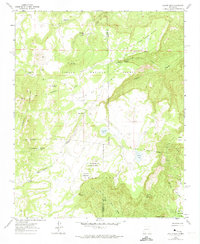
1961 Map of Laguna Seca
USGS Topo · Published 1974About this map
Cibola National Forest encompasses much of this high-desert landscape, where the McKinley and Sandoval County line divides the high mesas and deep canyons. The settlement pattern is defined by isolated outposts and water sources like Eagle Nest and the agricultural pocket at La Jolla Alfalfa. Water remains the central concern for those navigating this territory, evidenced by numerous tanks and springs such as Guadalupe Spring, North Spring, and the seasonal Laguna Seca. Massive geographic features like Mesa de la Vereda Piedra Blanca and Valle de las Animas dominate the terrain, while the Guadalupe Ranger Station serves as a lone administrative landmark in the wilderness. Small, localized place names like Cerritos de La Jolla de Santa Rosa hint at the area's deep Hispanic cultural roots and livestock history.
Find a feature on this map
38 named features on this map. Tap any name to fly to it.
Don’t see what you’re looking for? This feature index may not catch every label — zoom into the map to look around manually.
Map Details
Editions of this 1961 Laguna Seca Map
2 editions found
Other maps of this area

1883 · Mt. Taylor
USGS Topo · 1:250,000

1886 · Mt. Taylor
USGS Topo · 1:250,000

1892 · Mt. Taylor
USGS Topo · 1:250,000

1899 · Mt. Taylor
USGS Topo · 1:250,000

1958 · Albuquerque
USGS Topo · 1:250,000

1961 · Marquez
USGS Topo · 1:24,000

1961 · Cerro Parido
USGS Topo · 1:24,000

1961 · Cerro Tinaja
USGS Topo · 1:24,000

1961 · El Dado Mesa
USGS Topo · 1:24,000
1961 · La Gotera
USGS Topo · 1:24,000