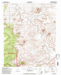
1995 Map of Guadalupe
USGS Topo · Published 1997About this map
The Ignacio Chavez Grant dominates this landscape in northwestern New Mexico, where the settlement of Guadalupe sits along the winding course of the Rio Puerco. This 1995 revision reveals a terrain defined by high mesas and deep canyons, including Cañon Guadalupe and Cañon Salado. The map shows several perennial water sources essential for livestock and habitation in this arid region, such as Ojo del Padre, Guadalupe Springs, and the Aranda Tank. Cultural markers like the Guadalupe Cemetery and the remote Banco de la Casa provide critical points of reference for genealogists and local historians. To the west, the boundary of the Cibola National Forest meets the land grant, while prominent volcanic plugs and mesas like Cerro de Guadalupe and Cerro Cuate punctuate the horizon, illustrating the complex geological history of the Rio Puerco valley.
Find a feature on this map
40 named features on this map. Tap any name to fly to it.
Don’t see what you’re looking for? This feature index may not catch every label — zoom into the map to look around manually.
Map Details
Editions of this 1995 Guadalupe Map
This is the sole edition of this map. No revisions or reprints were ever made.
Other maps of this area

1883 · Mt. Taylor
USGS Topo · 1:250,000

1886 · Mt. Taylor
USGS Topo · 1:250,000

1892 · Mt. Taylor
USGS Topo · 1:250,000

1899 · Mt. Taylor
USGS Topo · 1:250,000

1958 · Albuquerque
USGS Topo · 1:250,000

1961 · Cerro Parido
USGS Topo · 1:24,000

1961 · Cerro Tinaja
USGS Topo · 1:24,000

1961 · Arroyo Empedrado
USGS Topo · 1:24,000
1961 · Canada Calladita
USGS Topo · 1:24,000
1961 · Laguna Seca
USGS Topo · 1:24,000