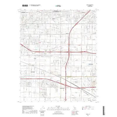
2018 Map of Guasti
USGS Topo · Published 2018About this map
Ontario International Airport dominates the central landscape of this Inland Empire survey, serving as a massive transit hub between the growing communities of Ontario, Rancho Cucamonga, and Fontana. This 2018 record shows the dense suburbanization that has transformed the valley floor, yet significant agricultural and industrial markers remain, such as the historic Guasti settlement and the smaller enclave of Champagne. The drainage patterns of Cucamonga Creek and Day Creek are shown as they channel runoff from the northern heights toward the Jurupa Mountains. Educational institutions like Platt College-Ontario and American Career College reflect the area's modern workforce development. At the northern edge, the legacy of rail infrastructure is visible in the Pacific Electric Trail, which follows the route of former electric lines through Alta Loma and Etiwanda. The map provides a detailed view of the complex freeway interchanges and residential street grids defining the San Bernardino and Riverside County border near Eastvale.
Find a feature on this map
49 named features on this map. Tap any name to fly to it.
Don’t see what you’re looking for? This feature index may not catch every label — zoom into the map to look around manually.
Map Details
Editions of this 2018 Guasti Map
This is the sole edition of this map. No revisions or reprints were ever made.
Other maps of this area

1896 · San Bernardino
USGS Topo · 1:62,500

1897 · Cucamonga
USGS Topo · 1:62,500

1898 · San Bernardino
USGS Topo · 1:62,500

1900 · Cucamonga
USGS Topo · 1:62,500

1901 · Southern California Sheet No. 1
USGS Topo · 1:250,000

1901 · San Bernardino
USGS Topo · 1:62,500

1901 · Elsinore
USGS Topo · 1:125,000

1901 · Riverside
USGS Topo · 1:62,500

1902 · Corona
USGS Topo · 1:125,000

1903 · Cucamonga
USGS Topo · 1:62,500