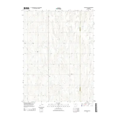
2014 Map of Guide Rock NE
USGS Topo · Published 2014About this map
Zion Cem and Beaver Creek Cem are part of a network of family and community burial grounds that define this agrarian section of the Nebraska-Kansas borderlands. The landscape is structured by an orderly grid of section-line roads, including Road 2100 and Road 2400, which provide access to small-scale water management features like Lemke Reservoir and Meents Reservoir.
Find a feature on this map
28 named features on this map. Tap any name to fly to it.
Don’t see what you’re looking for? This feature index may not catch every label — zoom into the map to look around manually.
Map Details
Editions of this 2014 Guide Rock NE Map
This is the sole edition of this map. No revisions or reprints were ever made.
Other maps of this area

1898 · Superior
USGS Topo · 1:125,000

1955 · Grand Island
USGS Topo · 1:250,000

1957 · Grand Island
USGS Topo · 1:250,000

1958 · Grand Island
USGS Topo · 1:250,000

1960 · Deweese
USGS Topo · 1:24,000

1969 · Lawrence
USGS Topo · 1:24,000

1969 · Blue Hill
USGS Topo · 1:24,000
1974 · Amboy
USGS Topo · 1:24,000
1974 · Guide Rock
USGS Topo · 1:24,000
1974 · Mount Clare
USGS Topo · 1:24,000