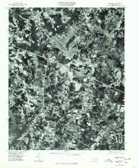
1977 Map of Guilford
USGS Topo · Published 1979About this map
Friendship and Guilford appear here during a period of significant suburban and infrastructure development in the late 1970s. This orthophotoquad provides a literal photographic view of the landscape, capturing the precise layout of roads and commercial footprints as they began to overlay the older agricultural patterns of the Piedmont. The southern portion of the map is dominated by the High Point Lake reservoir and the winding course of the Deep River, while the East Fork Deep River meanders through the northwest corner. To the east, South Buffalo Creek cuts through the area near Sedgefield, highlighting the natural drainage systems that dictated early settlement. Unlike traditional topographic maps, this aerial imagery allows researchers to see the exact density of residential clusters in Sandy Ridge and the specific land-use transitions surrounding the growing regional transport corridors.
Find a feature on this map
8 named features on this map. Tap any name to fly to it.
Don’t see what you’re looking for? This feature index may not catch every label — zoom into the map to look around manually.
Map Details
Editions of this 1977 Guilford Map
This is the sole edition of this map. No revisions or reprints were ever made.
Other maps of this area

1949 · High Point West
USGS Topo · 1:24,000

1950 · High Point East
USGS Topo · 1:24,000

1951 · High Point East
USGS Topo · 1:24,000

1951 · Guilford
USGS Topo · 1:24,000

1951 · Lake Brandt
USGS Topo · 1:24,000

1951 · Greensboro
USGS Topo · 1:24,000

1953 · Raleigh
USGS Topo · 1:250,000

1953 · Charlotte
USGS Topo · 1:250,000

1953 · Winston-Salem
USGS Topo · 1:250,000

1953 · Greensboro
USGS Topo · 1:250,000