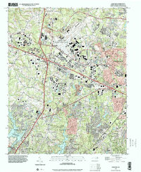
1997 Map of Guilford
USGS Topo · Published 2001About this map
Piedmont Triad International Airport serves as a dominant central landmark in this Greensboro-area study, illustrating the convergence of regional aviation with the late-twentieth-century expansion of surrounding Piedmont communities. The landscape is a complex network of established residential clusters and educational institutions, including the historic grounds of Guilford College and the local Guilford Sch. Waterways like the East Fork Deep River and Horsepen Creek weave through the terrain, which is punctuated by numerous community cornerstones such as New Salem Tabernacle, Raleigh Crossroads Ch, and Reynolds Chapel. These features, alongside the expansive Guilford Memorial Park and the recreational reaches of Oak Hollow Lake and High Point Lake, reflect the suburban and industrial growth typical of North Carolina's urban corridor during this era of development.
Find a feature on this map
34 named features on this map. Tap any name to fly to it.
Don’t see what you’re looking for? This feature index may not catch every label — zoom into the map to look around manually.
Map Details
Editions of this 1997 Guilford Map
This is the sole edition of this map. No revisions or reprints were ever made.
Other maps of this area

1949 · High Point West
USGS Topo · 1:24,000

1950 · High Point East
USGS Topo · 1:24,000

1951 · High Point East
USGS Topo · 1:24,000

1951 · Guilford
USGS Topo · 1:24,000

1951 · Lake Brandt
USGS Topo · 1:24,000

1951 · Greensboro
USGS Topo · 1:24,000

1953 · Raleigh
USGS Topo · 1:250,000

1953 · Charlotte
USGS Topo · 1:250,000

1953 · Winston-Salem
USGS Topo · 1:250,000

1953 · Greensboro
USGS Topo · 1:250,000