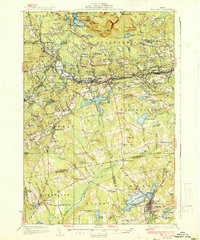
1937 Map of Guilford
USGS Topo · Published 1937About this map
Guilford and its surrounding Maine towns are defined by the winding course of the Piscataquis River, which supported the region's industry and rail infrastructure in the 1930s. The Bangor and Aroostook RR parallels the river through Abbot Village and Sangerville, while the narrow-gauge Monson RR terminates at Monson. This survey reveals a landscape densely dotted with rural social structures, including the Abbot Village School, French Hill School, and Smart School. Family-named landmarks such as Spooners Mill and Jackman Corner illustrate the localized economy of the era. The presence of numerous small bogs and ponds, like Robinson Bog and Manhanock Pond, highlights the complex glacial drainage patterns of the area. Genealogists will find value in the precisely marked cemeteries like Storer Cemetery and Mt Pleasant Cemetery located near the town of Dexter.
Find a feature on this map
116 named features on this map. Tap any name to fly to it.
Don’t see what you’re looking for? This feature index may not catch every label — zoom into the map to look around manually.
Map Details
Editions of this 1937 Guilford Map
2 editions found
Other maps of this area

1913 · Skowhegan
USGS Topo · 1:62,500

1930 · Pittsfield
USGS Topo · 1:48,000

1931 · Stetson
USGS Topo · 1:48,000

1932 · Dover-Foxcroft
USGS Topo · 1:48,000

1932 · Pittsfield
USGS Topo · 1:62,500

1933 · Pittsfield
USGS Topo · 1:62,500

1933 · Guilford
USGS Topo · 1:62,500

1935 · Dover-Foxcroft
USGS Topo · 1:62,500

1935 · Stetson
USGS Topo · 1:62,500

1937 · Guilford
USGS Topo · 1:62,500