1949 Map of Guinea
USGS Topo · Published 1961About this map
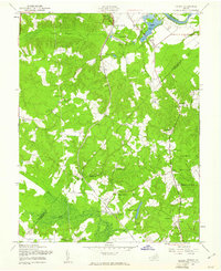
The Stonewall Jackson Shrine stands as a significant landmark in this mid-century portrait of the Virginia landscape where the Ni River, Po River, and Poni River converge. The Richmond Fredericksburg and Potomac railroad serves as the primary corridor through the region, connecting rail stops like Massaponax Sta and Hamiltons Crossing. This era shows a rural network of named crossroads and small communities, including Flippos Corner, Claiborne, and Old Sycamore.
Find a feature on this map
43 named features on this map. Tap any name to fly to it.
Don’t see what you’re looking for? This feature index may not catch every label — zoom into the map to look around manually.
Map Details
Editions of this 1949 Guinea Map
This is the sole edition of this map. No revisions or reprints were ever made.
Other maps of this area

1887 · Spottsylvania
USGS Topo · 1:125,000

1889 · Fredericksburg
USGS Topo · 1:125,000

1892 · Fredericksburg
USGS Topo · 1:125,000

1892 · Spottsylvania
USGS Topo · 1:125,000

1894 · Fredericksburg
USGS Topo · 1:125,000

1926 · Stafford
USGS Topo · 1:62,500

1931 · Stafford
USGS Topo · 1:62,500

1942 · Bowling Green
USGS Topo · 1:31,680

1942 · Woodford
USGS Topo · 1:31,680

1942 · Guinea
USGS Topo · 1:31,680