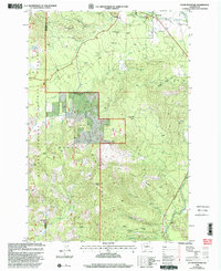
1998 Map of Guler Mountain
USGS Topo · Published 2003About this map
Trout Lake and the northern reaches of the Gifford Pinchot National Forest define this landscape at the edge of the Monte Cristo Range. The map reveals a legacy of timber processing, noting the locations of the Gablehouse Mill (Site) and Smeltzer Mill (Site) along the slopes above the White Salmon River. This area is geologically distinct for its extensive subterranean features, including named locations such as Cheese Cave, Butter Cave, and the Christmas Tree Cave.
Find a feature on this map
37 named features on this map. Tap any name to fly to it.
Don’t see what you’re looking for? This feature index may not catch every label — zoom into the map to look around manually.
Map Details
Editions of this 1998 Guler Mountain Map
This is the sole edition of this map. No revisions or reprints were ever made.
Other maps of this area

1904 · Mount Adams
USGS Topo · 1:125,000

1907 · Mount Adams
USGS Topo · 1:125,000

1926 · Steamboat Mtn
USGS Topo · 1:125,000

1926 · Hood River
USGS Topo · 1:125,000

1929 · Hood River
USGS Topo · 1:125,000

1931 · Steamboat Mtn
USGS Topo · 1:125,000

1934 · The Dalles
USGS Topo · 1:125,000

1950 · Yakima
USGS Topo · 1:250,000

1953 · The Dalles
USGS Topo · 1:250,000

1956 · The Dalles
USGS Topo · 1:250,000