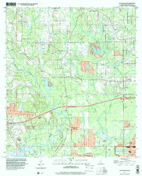
1997 Map of Gulfport NW
USGS Topo · Published 2000About this map
The Wolf River winds through the western reaches of Harrison County, shaping a landscape defined by its coastal bayous and emerging suburban developments near the Mississippi Sound. This late-twentieth-century study of the area north of Long Beach and Gulfport reveals a mix of older rural landmarks and significant government installations. The U S Naval Reservation occupies a substantial footprint in the southeast, while the interior is dotted with community centers like Our Lady of Mercy Ch and Michael Memorial Ch. A unique historical layer is preserved in the Alexander Dimitry Claim, a legacy of early land grants that persists alongside the modern infrastructure of Interchange 31. Water management is prominent throughout the quadrangle, evidenced by Canal No 1, Canal No 2, and a series of levees protecting local settlements such as Jones Mill and New Hope.
Find a feature on this map
33 named features on this map. Tap any name to fly to it.
Don’t see what you’re looking for? This feature index may not catch every label — zoom into the map to look around manually.
Map Details
Editions of this 1997 Gulfport NW Map
This is the sole edition of this map. No revisions or reprints were ever made.
Other maps of this area

1953 · Mobile
USGS Topo · 1:250,000

1954 · McHenry
USGS Topo · 1:62,500

1954 · Gulfport North
USGS Topo · 1:24,000

1954 · Gulfport South
USGS Topo · 1:24,000

1955 · Savannah
USGS Topo · 1:62,500

1955 · Pass Christian
USGS Topo · 1:24,000

1956 · Bay St. Louis
USGS Topo · 1:24,000

1956 · Vidalia
USGS Topo · 1:24,000

1956 · Gulfport NW
USGS Topo · 1:24,000

1957 · Mobile
USGS Topo · 1:250,000