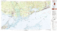
1982 Map of Gulfport
USGS Topo · Published 1983About this map
The coastal interface between New Orleans and Gulfport is defined by a dense network of bayous and marshlands at the turn of the 1980s. This survey illustrates the proximity of high-technology aerospace infrastructure, notably the National Space Technology Laboratories, to older river settlements like Gainesville and Logtown along the Pearl River. The intricate hydrology of the Rigolets and Chef Menteur Pass serves as the primary connection between Lake Pontchartrain and the Mississippi Sound, highlighting the importance of the Intracoastal Waterway for regional navigation.
Find a feature on this map
113 named features on this map. Tap any name to fly to it.
Don’t see what you’re looking for? This feature index may not catch every label — zoom into the map to look around manually.
Map Details
Editions of this 1982 Gulfport Map
2 editions found
Other maps of this area

1891 · Spanish Fort
USGS Topo · 1:62,500

1891 · New Orleans
USGS Topo · 1:62,500

1892 · Chef Menteur
USGS Topo · 1:62,500

1892 · St. Bernard
USGS Topo · 1:62,500

1893 · Cat Island
USGS Topo · 1:62,500

1893 · Rigolets
USGS Topo · 1:62,500

1893 · Chandeleur
USGS Topo · 1:62,500

1893 · Shell Beach
USGS Topo · 1:62,500

1893 · Toulme
USGS Topo · 1:62,500

1895 · Bodreau
USGS Topo · 1:62,500