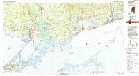
1982 Map of Gulfport
USGS Topo · Published 1983About this map
The delta of the Pearl River and the sweeping shoreline of the Mississippi Sound dominate this early 1980s survey, showing the complex aquatic boundary between Louisiana and Mississippi. The vast marshlands and river channels of the Pearl River State Wildlife Management Area and the State Game Preserve separate the growing hub of Slidell from the coastal communities of Bay St Louis and Pass Christian. Inland, the landscape is defined by the massive footprint of the National Space Technology Laboratories, a critical aerospace site tucked between the Wolf River and Jourdan River. From the Gulfport Airport to the training grounds at Camp Villere, the map documents a region balanced between military and scientific federal installations, industrial rail lines like the Southern Railway System, and the established resort character of the Gulf coast.
Find a feature on this map
209 named features on this map. Tap any name to fly to it.
Don’t see what you’re looking for? This feature index may not catch every label — zoom into the map to look around manually.
Map Details
Editions of this 1982 Gulfport Map
2 editions found
Other maps of this area

1891 · Spanish Fort
USGS Topo · 1:62,500

1891 · New Orleans
USGS Topo · 1:62,500

1892 · Chef Menteur
USGS Topo · 1:62,500

1892 · St. Bernard
USGS Topo · 1:62,500

1893 · Cat Island
USGS Topo · 1:62,500

1893 · Rigolets
USGS Topo · 1:62,500

1893 · Chandeleur
USGS Topo · 1:62,500

1893 · Shell Beach
USGS Topo · 1:62,500

1893 · Toulme
USGS Topo · 1:62,500

1895 · Bodreau
USGS Topo · 1:62,500