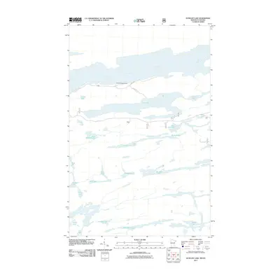
2011 Map of Gunflint Lake
USGS Topo · Published 2011About this map
The Gunflint Seaplane Base stands as a focal point of infrastructure in this wilderness region along the Minnesota-Ontario border, reflecting the aviation-dependent nature of remote northern travel. This network of glacial lakes and interconnecting waterways, including Loon Lake and the elongated Kiskadinna Lake, illustrates a landscape where movement is dictated by the water rather than the few overland routes like S Gunflint Lake Rd. Small roads such as Mile O' Pine provide limited access to the northern shorelines, while the interior remains a dense labyrinth of drainages like Banadad Creek and Finn Creek. The map documents a complex aquatic geography where even small bodies of water like Little Iron Lake and Mash Lake serve as critical landmarks for navigation in a region largely defined by the Superior National Forest and neighboring Canadian wilderness.
Find a feature on this map
29 named features on this map. Tap any name to fly to it.
Don’t see what you’re looking for? This feature index may not catch every label — zoom into the map to look around manually.
Map Details
Editions of this 2011 Gunflint Lake Map
This is the sole edition of this map. No revisions or reprints were ever made.
Other maps of this area

1919 · Brule Lake
USGS Topo · 1:62,500

1954 · Two Harbors
USGS Topo · 1:250,000

1957 · Two Harbors
USGS Topo · 1:250,000

1957 · Quetico
USGS Topo · 1:250,000

1958 · Two Harbors
USGS Topo · 1:250,000

1959 · Conners Island
USGS Topo · 1:24,000
1960 · South Lake
USGS Topo · 1:24,000
1960 · Eagle Mountain
USGS Topo · 1:24,000

1960 · Brule Lake
USGS Topo · 1:24,000
1960 · Cherokee Lake
USGS Topo · 1:24,000