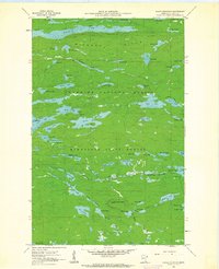
1960 Map of Eagle Mountain
USGS Topo · Published 1962About this map
Eagle Mountain and the surrounding Misquah Hills anchor this 1960 survey of a lake-dense wilderness in the Superior National Forest. This interior region of Cook County is characterized by long, narrow water bodies like Winchell Lake and the irregular, island-dotted expanse of Brule Lake, which includes Brule Island and Brule Bay. The map documents a landscape almost entirely devoid of modern roads, defined instead by the hydrography of the Minnesota State Forest and the remnants of industrial history.
Find a feature on this map
64 named features on this map. Tap any name to fly to it.
Don’t see what you’re looking for? This feature index may not catch every label — zoom into the map to look around manually.
Map Details
Editions of this 1960 Eagle Mountain Map
3 editions found
Other maps of this area

1919 · Brule Lake
USGS Topo · 1:62,500

1954 · Two Harbors
USGS Topo · 1:250,000

1957 · Two Harbors
USGS Topo · 1:250,000

1957 · Quetico
USGS Topo · 1:250,000

1958 · Two Harbors
USGS Topo · 1:250,000

1959 · Lima Mountain
USGS Topo · 1:24,000

1959 · Hungry Jack Lake
USGS Topo · 1:24,000

1960 · Tait Lake
USGS Topo · 1:24,000
1960 · Devil Track Lake
USGS Topo · 1:24,000

1960 · Mark Lake
USGS Topo · 1:24,000