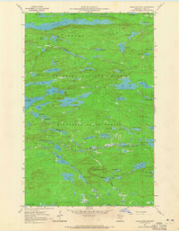
1960 Map of Eagle Mountain
USGS Topo · Published 1965About this map
Eagle Mountain and the surrounding Misquah Hills dominate this survey of the Boundary Waters region, as recorded in the early 1960s. The landscape is defined by an intricate network of glacial lakes including the sprawling Winchell Lake and Brule Lake. While much of the area is protected within the Superior National Forest and Minnesota State Forest, evidence of earlier industrial activity remains. An Old Railroad Grade winds through the northeast, tracing a path south of Swan Lake toward Lac Lake, while a small Gravel Pit marks a rare point of modern excavation. The map captures a moment when this wilderness was documented with high topographic precision, featuring landmarks like Brule Island and Brule Rapids alongside numerous smaller bodies of water such as Footsteps Lake and Skinny Lake.
Find a feature on this map
66 named features on this map. Tap any name to fly to it.
Don’t see what you’re looking for? This feature index may not catch every label — zoom into the map to look around manually.
Map Details
Editions of this 1960 Eagle Mountain Map
3 editions found
Other maps of this area

1919 · Brule Lake
USGS Topo · 1:62,500

1954 · Two Harbors
USGS Topo · 1:250,000

1957 · Two Harbors
USGS Topo · 1:250,000

1957 · Quetico
USGS Topo · 1:250,000

1958 · Two Harbors
USGS Topo · 1:250,000

1959 · Lima Mountain
USGS Topo · 1:24,000

1959 · Hungry Jack Lake
USGS Topo · 1:24,000

1960 · Tait Lake
USGS Topo · 1:24,000
1960 · Devil Track Lake
USGS Topo · 1:24,000

1960 · Mark Lake
USGS Topo · 1:24,000