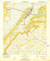
1950 Map of Guntersville
USGS Topo · Published 1950About this map
Guntersville serves as the focal point of this postwar Tennessee Valley Authority survey, situated where the Guntersville Reservoir meets the dramatic slopes of Sand Mountain. The map illustrates a transitional period for the town's economy, showing the vital N C & St L Ry Ferry slip and a prominent pumping station alongside industrial areas like Mill Village. Transportation is a key theme, with the Florida Short Route and Houston Bridge providing critical regional connections across the water.
Find a feature on this map
72 named features on this map. Tap any name to fly to it.
Don’t see what you’re looking for? This feature index may not catch every label — zoom into the map to look around manually.
Map Details
Editions of this 1950 Guntersville Map
This is the sole edition of this map. No revisions or reprints were ever made.
Other maps of this area

1885 · Gadsden
USGS Topo · 1:125,000

1888 · Gadsden
USGS Topo · 1:125,000

1892 · Gadsden
USGS Topo · 1:125,000

1895 · Gadsden
USGS Topo · 1:125,000

1903 · Gadsden
USGS Topo · 1:125,000

1936 · Guntersville
USGS Topo · 1:24,000

1936 · Mountainboro
USGS Topo · 1:24,000

1936 · Columbus City
USGS Topo · 1:24,000

1936 · Guntersville Dam
USGS Topo · 1:24,000

1936 · Arab
USGS Topo · 1:24,000