Loading...
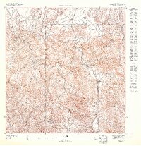
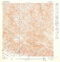
Loading map...1947 Map of Gurabo NE
USGS Topo · Published 1947This historical map portrays the area of Gurabo NE in 1947, primarily covering Canóvanas Municipio as well as portions of Carolina Municipio and Río Grande Municipio. Featuring a scale of 1:10000, this map provides a highly detailed snapshot of the terrain, roads, buildings, counties, and historical landmarks in the Gurabo NE region at the time. Published in 1947, it is the sole known edition of this map.
Map Details
Date Portrayed1947
Date Published1947
PublisherU.S. Geological Survey
Map TypeTopographic
Scale1:10000
Physical Dimensions30.62 x 31.67 inches
Editions of this 1947 Gurabo NE Map
This is the sole edition of this map. No revisions or reprints were ever made.
Historical Maps of Estancias de Campo Rico Through Time
Featured Locations
- La Marina, Canóvanas
- Mansiones del Tesoro, Canóvanas
- Cambalache, Canóvanas
- Estancias de Campo Rico, Canóvanas
- Sector Los Canales, Carolina
Source Details
SourceU.S. Geological Survey
CopyrightPublic Domain