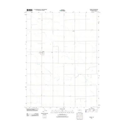
2011 Map of Gurley
USGS Topo · Published 2011About this map
Gurley serves as the central hub of this Cheyenne County landscape, organized around its grid of agricultural roads and the Gurley Post Office. The township layout is defined by a strict cardinal road system, with thoroughfares like Road 46 and Road 111 sectioning the prairie into large agricultural tracts. This 2011 survey captures the area’s reliance on these established corridors, which connect isolated homesteads to the village core. Crossing the southern portion of the quadrangle, the winding path of Rush Creek provides a natural contrast to the geometric regularity of the surrounding farm lots. To the northeast, Babb Cemetery stands as a quiet marker of the region’s long-standing community roots, while the extensive network of local roads—from Road 36 in the south to Road 52 in the north—illustrates the modern connectivity of this High Plains farming district.
Find a feature on this map
18 named features on this map. Tap any name to fly to it.
Don’t see what you’re looking for? This feature index may not catch every label — zoom into the map to look around manually.
Map Details
Editions of this 2011 Gurley Map
This is the sole edition of this map. No revisions or reprints were ever made.
Other maps of this area

1899 · Sidney
USGS Topo · 1:125,000

1954 · Scottsbluff
USGS Topo · 1:250,000

1958 · Scottsbluff
USGS Topo · 1:250,000

1972 · Gurley
USGS Topo · 1:24,000
1972 · Fairchild Ranch
USGS Topo · 1:24,000
1972 · Dalton
USGS Topo · 1:24,000

1972 · Brownson
USGS Topo · 1:24,000

1972 · Mud Springs SE
USGS Topo · 1:24,000

1972 · Sunol
USGS Topo · 1:24,000
1972 · Mud Springs
USGS Topo · 1:24,000