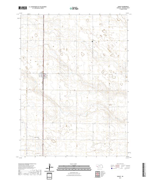
2021 Map of Gurley
USGS Topo · Published 2021About this map
The village of Gurley sits at the heart of this Cheyenne County landscape, organized along a traditional grid of streets including Washington St, Front St, and 1st St. This survey reflects the agricultural character of the Nebraska Panhandle, where the land is partitioned by a meticulous network of section roads like RD 113 and RD 46. The terrain is defined by the winding path of Rush Cr, which carves through the southern half of the quadrangle near the prominent Cedar Canyon. This area provides a clear view of the rural spatial organization in the early 21st century, centered on the community and the lone Union Valley Cem to the northeast, which serves as a quiet marker of the region's local heritage and family lineages.
Find a feature on this map
28 named features on this map. Tap any name to fly to it.
Don’t see what you’re looking for? This feature index may not catch every label — zoom into the map to look around manually.
Map Details
Editions of this 2021 Gurley Map
This is the sole edition of this map. No revisions or reprints were ever made.
Other maps of this area

1899 · Sidney
USGS Topo · 1:125,000

1954 · Scottsbluff
USGS Topo · 1:250,000

1958 · Scottsbluff
USGS Topo · 1:250,000

1972 · Gurley
USGS Topo · 1:24,000
1972 · Fairchild Ranch
USGS Topo · 1:24,000
1972 · Dalton
USGS Topo · 1:24,000

1972 · Brownson
USGS Topo · 1:24,000

1972 · Mud Springs SE
USGS Topo · 1:24,000

1972 · Sunol
USGS Topo · 1:24,000
1972 · Mud Springs
USGS Topo · 1:24,000