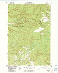
1984 Map of Gurney
USGS Topo · Published 1984About this map
The Bad River Indian Reservation dominates the western landscape of this mid-1980s survey, where the winding Potato River carves through the terrain to create the Potato River Falls. The small settlement of Gurney serves as a local hub near the Soo Line Railroad, which parallels the river as it moves through the eastern portion of the quadrangle. This era shows a community defined by its remote township boundaries and a network of named rural routes like Vogues Road and Stricker Road.
Find a feature on this map
30 named features on this map. Tap any name to fly to it.
Don’t see what you’re looking for? This feature index may not catch every label — zoom into the map to look around manually.
Map Details
Editions of this 1984 Gurney Map
This is the sole edition of this map. No revisions or reprints were ever made.
Other maps of this area

1940 · Upson
USGS Topo · 1:48,000

1942 · Mellen
USGS Topo · 1:48,000

1943 · Upson
USGS Topo · 1:48,000

1943 · Little Girl Point
USGS Topo · 1:48,000

1943 · Odanah
USGS Topo · 1:48,000

1945 · Odanah
USGS Topo · 1:48,000

1945 · Mellen
USGS Topo · 1:48,000

1953 · Ashland
USGS Topo · 1:250,000
1956 · Saxon
USGS Topo · 1:24,000
1956 · Upson
USGS Topo · 1:24,000