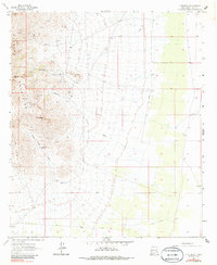
1964 Map of Gym Peak
USGS Topo · Published 1986About this map
Florida Mountains dominate this 1960s landscape, where mining interests and livestock ranching intersect in the high desert of Luna County. The terrain is marked by numerous mineral extraction sites, including the Atir Mine, Sun Tex Mine, and Mahoney Mine, which are accessed by a network of Jeep Trails winding through the canyons. Notable summits like Gym Peak and Baldy Peak tower over the surrounding draws, while the necessity of water in this arid environment is evident in the scattered locations of improvements like English Well, Victorio Well, and the Copper Kettle Well. Ranching infrastructure is further detailed by the inclusion of a Water Tank and several Blue Water Wells, illustrating how human activity adapted to the severe topography of Victorio Canyon and Lobo Draw before modern developments reached this corner of New Mexico.
Find a feature on this map
31 named features on this map. Tap any name to fly to it.
Don’t see what you’re looking for? This feature index may not catch every label — zoom into the map to look around manually.
Map Details
Editions of this 1964 Gym Peak Map
2 editions found

Other maps of this area

1899 · Deming
USGS Topo · 1:125,000

1915 · Deming
USGS Topo · 1:125,000

1917 · Camel Mountain
USGS Topo · 1:62,500

1917 · Columbus
USGS Topo · 1:62,500

1918 · Columbus
USGS Topo · 1:62,500

1920 · Columbus
USGS Topo · 1:62,500

1953 · El Paso
USGS Topo · 1:250,000

1955 · Las Cruces
USGS Topo · 1:250,000

1958 · Las Cruces
USGS Topo · 1:250,000

1959 · El Paso
USGS Topo · 1:250,000