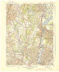
1940 Map of Hackensack
USGS Topo · Published 1940About this map
The Hackensack River valley in the mid-1930s shows an intensive network of residential expansion and recreation, anchored by the massive Oradell Reservoir to the north. This period captures the suburbanization of Bergen County, where planned communities like Radburn sit alongside older established centers such as Hackensack, Ridgewood, and Garfield. The landscape is notably dotted with social and institutional landmarks, from the Bergen Pines County Hospital to a high concentration of private recreation grounds like the Arcola Golf Club and Ridgewood Golf Club.
Find a feature on this map
80 named features on this map. Tap any name to fly to it.
Don’t see what you’re looking for? This feature index may not catch every label — zoom into the map to look around manually.
Map Details
Editions of this 1940 Hackensack Map
3 editions found
Other maps of this area

1888 · Paterson
USGS Topo · 1:62,500

1891 · Ramapo
USGS Topo · 1:62,500

1891 · Harlem
USGS Topo · 1:62,500

1892 · Paterson
USGS Topo · 1:62,500

1892 · Tarrytown
USGS Topo · 1:62,500

1893 · Tarrytown
USGS Topo · 1:62,500

1893 · Ramapo
USGS Topo · 1:62,500

1897 · Harlem
USGS Topo · 1:62,500

1898 · Harlem
USGS Topo · 1:62,500

1898 · Paterson
USGS Topo · 1:62,500