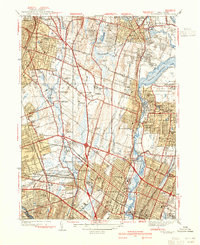
1940 Map of Hackensack
USGS Topo · Published 1940About this map
Hackensack and its surrounding boroughs are mapped here just before the massive post-war suburban expansion transformed Bergen County. The landscape is defined by the Hackensack River and the significant footprint of the Oradell Reservoir to the north, which dominates the topography near Oradell and Haworth. Transit networks of the Erie RR connect established commuter hubs like Ridgewood and Westwood, while the early residential experiment of Radburn in Fair Lawn appears in its planned form. Local history is preserved in the numerous burial grounds such as Valleau Cem and Old Hook Cem, and the presence of several country clubs, including the Arcola Golf Club and White Beeches Golf Club, suggests the recreational character of the region during this era. Public infrastructure is noted through landmarks like the Courthouse and the Bergen Pines County Hospital, reflecting the county seat's central role.
Find a feature on this map
73 named features on this map. Tap any name to fly to it.
Don’t see what you’re looking for? This feature index may not catch every label — zoom into the map to look around manually.
Map Details
Editions of this 1940 Hackensack Map
3 editions found
Other maps of this area

1888 · Paterson
USGS Topo · 1:62,500

1891 · Ramapo
USGS Topo · 1:62,500

1891 · Harlem
USGS Topo · 1:62,500

1892 · Paterson
USGS Topo · 1:62,500

1892 · Tarrytown
USGS Topo · 1:62,500

1893 · Tarrytown
USGS Topo · 1:62,500

1893 · Ramapo
USGS Topo · 1:62,500

1897 · Harlem
USGS Topo · 1:62,500

1898 · Harlem
USGS Topo · 1:62,500

1898 · Paterson
USGS Topo · 1:62,500