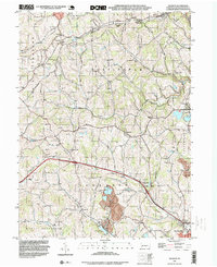
1993 Map of Hackett
USGS Topo · Published 1999About this map
Pigeon Creek and its various branches carve through the landscape of Washington County, defining the settlement patterns of Somerset and Nottingham townships. The map reveals an area deeply rooted in transport and extraction, featuring the Thomas Tunnel and the prominent Strip Mine south of Kammerer. For those tracing local families, the presence of several established burial grounds such as Munnstown Cem and Somerset Twp Cem offers specific geographic anchors for genealogical research.
Find a feature on this map
40 named features on this map. Tap any name to fly to it.
Don’t see what you’re looking for? This feature index may not catch every label — zoom into the map to look around manually.
Map Details
Editions of this 1993 Hackett Map
This is the sole edition of this map. No revisions or reprints were ever made.
Other maps of this area

1901 · Amity
USGS Topo · 1:62,500

1902 · Brownsville
USGS Topo · 1:62,500

1904 · Amity
USGS Topo · 1:62,500

1904 · Mc Keesport
USGS Topo · 1:62,500

1904 · Carnegie
USGS Topo · 1:62,500

1906 · Brownsville
USGS Topo · 1:62,500

1906 · Carnegie
USGS Topo · 1:62,500

1907 · Pittsburg
USGS Topo · 1:62,500

1908 · Carnegie
USGS Topo · 1:62,500

1931 · Brownsville
USGS Topo · 1:62,500
Featured Places
- Bentleyville, PA
- Thomas, Nottingham Township
- Kammerer, Nottingham Township
- Vanceville, Somerset Township
- Venetia, Peters Township