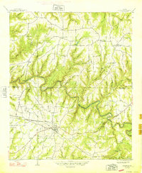
1948 Map of Hackleburg
USGS Topo · Published 1948About this map
Hackleburg serves as the primary hub in this late 1940s landscape, positioned where the Illinois Central railroad cuts through the terrain. The area is defined by the winding course of Bear Creek, which creates dramatic natural features such as Bailey Bend and Horseshoe Bend. Transportation history is prominently recorded through the path of the Military Road and its crossing at Military Bridge, indicating the historical significance of this corridor for regional movement across the deep hollows of Franklin and Marion counties.
Find a feature on this map
84 named features on this map. Tap any name to fly to it.
Don’t see what you’re looking for? This feature index may not catch every label — zoom into the map to look around manually.
Map Details
Editions of this 1948 Hackleburg Map
2 editions found
Other maps of this area

1936 · Hodges
USGS Topo · 1:24,000

1936 · Isbell
USGS Topo · 1:24,000

1936 · Phil Campbell
USGS Topo · 1:24,000

1936 · South Of Hackleburg
USGS Topo · 1:24,000

1936 · Hackleburg
USGS Topo · 1:24,000

1936 · Spruce Pine
USGS Topo · 1:24,000

1936 · Goddard
USGS Topo · 1:24,000

1936 · Guinn Cross Roads
USGS Topo · 1:24,000

1945 · Spruce Pine
USGS Topo · 1:24,000
1945 · Isbell
USGS Topo · 1:24,000