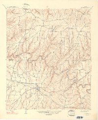
1948 Map of Hackleburg
USGS Topo · Published 1948About this map
Hackleburg serves as the central hub of this 1948 survey, showing the town's alignment along the Illinois Central railroad and a network of early country roads. The landscape is defined by the winding course of Bear Creek, which creates deep bends like Bear Creek Bend as it crosses from the Franklin Co / Marion Co boundary. The prevalence of family-named landmarks such as Nix Mill and numerous cemeteries including Cleveland Cem, Lindsey Cem, and the uniquely named Burnt House Cem indicates a long-settled rural community. Educational and spiritual life is marked by sites like Ballrock Sch, Gravel Hill Sch, and Adams Chapel. Historical transport routes are anchored by the Military Road and Military Bridge, reflecting the enduring path of older logistical corridors through the Alabama uplands.
Find a feature on this map
76 named features on this map. Tap any name to fly to it.
Don’t see what you’re looking for? This feature index may not catch every label — zoom into the map to look around manually.
Map Details
Editions of this 1948 Hackleburg Map
2 editions found
Other maps of this area

1936 · Hodges
USGS Topo · 1:24,000

1936 · Isbell
USGS Topo · 1:24,000

1936 · Phil Campbell
USGS Topo · 1:24,000

1936 · South Of Hackleburg
USGS Topo · 1:24,000

1936 · Hackleburg
USGS Topo · 1:24,000

1936 · Spruce Pine
USGS Topo · 1:24,000

1936 · Goddard
USGS Topo · 1:24,000

1936 · Guinn Cross Roads
USGS Topo · 1:24,000

1945 · Spruce Pine
USGS Topo · 1:24,000
1945 · Isbell
USGS Topo · 1:24,000