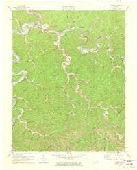
1972 Map of Haddix
USGS Topo · Published 1973About this map
Troublesome Creek and the North Fork Kentucky River dominate this 1970s landscape, where winding waterways dictate the layout of Breathitt County's hollows and ridges. The Louisville and Nashville Railroad snakes through the river valley, serving settlements like Haddix and Copland. This survey captures a community deeply rooted in the land, evidenced by numerous family burial grounds including Haddix Cem and Thorpe Cem. Educational and spiritual life centers around the Riverside Christian Training Sch near the mouth of Lost Creek, while New Bethlehem Ch serves the residents around Clayhole. The topography is marked by significant elevations like Elkbutt Knob and Hickory Gap, with a Lookout Tower positioned for forest surveillance. Small-scale industry is visible in a Mine near the northern bend of the river, reflecting the region's enduring reliance on natural resources and rail transport.
Find a feature on this map
50 named features on this map. Tap any name to fly to it.
Don’t see what you’re looking for? This feature index may not catch every label — zoom into the map to look around manually.
Map Details
Editions of this 1972 Haddix Map
This is the sole edition of this map. No revisions or reprints were ever made.
Other maps of this area

1889 · Salyersville
USGS Topo · 1:125,000

1891 · Hazard
USGS Topo · 1:125,000

1891 · Salyersville
USGS Topo · 1:125,000

1899 · Salyersville
USGS Topo · 1:125,000

1913 · Buckhorn
USGS Topo · 1:62,500

1914 · Troublesome
USGS Topo · 1:62,500

1951 · Guage
USGS Topo · 1:24,000

1951 · Quicksand
USGS Topo · 1:24,000

1951 · Jackson
USGS Topo · 1:24,000

1953 · Buckhorn
USGS Topo · 1:24,000