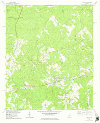
1978 Map of Haddock
USGS Topo · Published 1978About this map
The community of Haddock serves as a central hub for this portion of Jones County during the late 1970s, where the Georgia railroad line runs parallel to the primary local thoroughfare. The landscape transitions from the protected woodland of the Oconee National Forest in the northwest toward a series of established settlements and family-named landmarks. The mapping of Fortville, Blountsville, and Pineville reveals a rural layout defined by small churches and burial grounds, such as Blounts Chapel Cem and Ellis Chapel Cem, which anchor the local geography. Waterways including Potato Creek and Commissioner Creek drain the area toward Lake Jonesco, while an Indefinite Boundary marks the division between Jones and Baldwin Counties. The concentration of structures in Haddock near the Water Tank and the presence of a local Golf Course reflect the development patterns of this Middle Georgia region during this era.
Find a feature on this map
28 named features on this map. Tap any name to fly to it.
Don’t see what you’re looking for? This feature index may not catch every label — zoom into the map to look around manually.
Map Details
Editions of this 1978 Haddock Map
This is the sole edition of this map. No revisions or reprints were ever made.
Other maps of this area

1953 · Athens
USGS Topo · 1:250,000

1956 · Gordon
USGS Topo · 1:62,500

1956 · Macon
USGS Topo · 1:62,500

1957 · Macon
USGS Topo · 1:250,000

1958 · Macon
USGS Topo · 1:250,000

1958 · Athens
USGS Topo · 1:250,000

1959 · Athens
USGS Topo · 1:250,000

1963 · Athens
USGS Topo · 1:250,000

1964 · Macon
USGS Topo · 1:250,000

1964 · Gray
USGS Topo · 1:24,000