
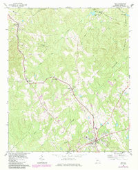
1964 Map of Gray
USGS Topo · Published 1965About this map
The Central Of Georgia railroad anchors the local geography of Jones County, carving a path through the southern reaches of the Oconee National Forest. Small community centers like Bradley, Wayside, and Round Oak align with this transit corridor, which historically supported the region's agricultural and timber economy. The transition from the dense woodlands of the national forest to the more developed hub at Gray is evident, with the township featuring a centralized Water Tank and several cemeteries near the historic settlement of Clinton.
Find a feature on this map
24 named features on this map. Tap any name to fly to it.
Don’t see what you’re looking for? This feature index may not catch every label — zoom into the map to look around manually.
Map Details
Editions of this 1964 Gray Map
2 editions found
Other maps of this area

1953 · Athens
USGS Topo · 1:250,000

1956 · Gordon
USGS Topo · 1:62,500

1956 · Macon
USGS Topo · 1:62,500

1957 · Macon
USGS Topo · 1:250,000

1958 · Macon
USGS Topo · 1:250,000

1958 · Athens
USGS Topo · 1:250,000

1959 · Athens
USGS Topo · 1:250,000

1963 · Athens
USGS Topo · 1:250,000

1964 · Macon
USGS Topo · 1:250,000
1964 · Dames Ferry
USGS Topo · 1:24,000