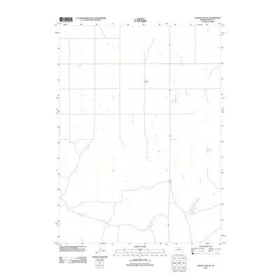
2011 Map of Hagan Lake NE
USGS Topo · Published 2011About this map
Thurman Cemetery serves as a central landmark in this portion of northern Nebraska, situated in a landscape defined by an extensive network of ephemeral water bodies and isolated basins. The geography of Rock County is captured here in 2011, showing the modern alignment of State Highway 183 as it cuts north-to-south through the center of the quadrangle. This area of the Sandhills transition is characterized by a sparse human footprint, where section lines and local roads provide the primary structure for ranching and land management. The concentration of small, unnamed wetlands throughout the terrain illustrates the unique hydrography of the region, where seasonal water levels dictate the use of the surrounding plains.
Find a feature on this map
2 named features on this map. Tap any name to fly to it.
Don’t see what you’re looking for? This feature index may not catch every label — zoom into the map to look around manually.
Map Details
Editions of this 2011 Hagan Lake NE Map
This is the sole edition of this map. No revisions or reprints were ever made.
Other maps of this area

1954 · Long Pine
USGS Topo · 1:24,000

1954 · Bassett
USGS Topo · 1:24,000

1954 · Newport SW
USGS Topo · 1:24,000

1955 · O'Neill
USGS Topo · 1:250,000

1959 · O'Neill
USGS Topo · 1:250,000

1969 · O'Neill
USGS Topo · 1:250,000
1982 · Linke Lake
USGS Topo · 1:24,000

1982 · Hagan Lake NE
USGS Topo · 1:24,000

1982 · Stockdale Lake
USGS Topo · 1:24,000
1982 · Lake George
USGS Topo · 1:24,000