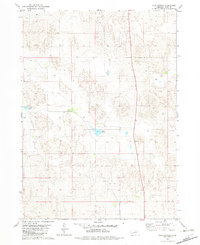
1982 Map of Lake George
USGS Topo · Published 1982About this map
The Nebraska Sandhills landscape of Rock County is defined by its characteristic depressions and wetlands, centered around Lake George. This 1982 survey reveals a sparsely populated ranching region where the presence of the Helm Ranch stands as a primary landmark for local history and genealogy. The terrain is marked by numerous basins, including Cark Lake, which are characteristic of this unique physiographic province. A notable north-south transportation artery, Route 183, bisects the eastern portion of the quadrangle, providing the principal access through the undulating dune-like topography. Smaller features like the Wc landmark and various scattered wells suggest the critical role of water management in this high plains environment during the late 1970s and early 1980s.
Find a feature on this map
9 named features on this map. Tap any name to fly to it.
Don’t see what you’re looking for? This feature index may not catch every label — zoom into the map to look around manually.
Map Details
Editions of this 1982 Lake George Map
This is the sole edition of this map. No revisions or reprints were ever made.
Other maps of this area

1955 · O'Neill
USGS Topo · 1:250,000

1959 · O'Neill
USGS Topo · 1:250,000

1969 · O'Neill
USGS Topo · 1:250,000

1981 · Stonehouse Ranch NW
USGS Topo · 1:24,000

1981 · Paramount Valley
USGS Topo · 1:24,000

1981 · Rose
USGS Topo · 1:24,000
1982 · Linke Lake
USGS Topo · 1:24,000

1982 · Hagan Lake NE
USGS Topo · 1:24,000

1982 · Stockdale Lake
USGS Topo · 1:24,000
1982 · Hagan Lake
USGS Topo · 1:24,000