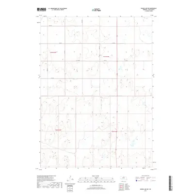
2017 Map of Hagan Lake NE
USGS Topo · Published 2017About this map
Thurman Cem stands as a focal point for family history in this corner of Rock County, situated along a landscape defined by an orderly grid of section lines and rural tracks. The terrain is marked by numerous depressions and wetlands typical of the Nebraska Sandhills, where the lack of major urban development preserves the original land divisions of t29n r20w and t29n r19w. Transportation in the area relies on a network of numbered section roads, including 874th Rd and 871st Rd, which provide access to remote ranching properties and small localized water features. The presence of WPA Rd offers a literal connection to New Deal-era infrastructure projects that shaped the rural interior of the Great Plains.
Find a feature on this map
10 named features on this map. Tap any name to fly to it.
Don’t see what you’re looking for? This feature index may not catch every label — zoom into the map to look around manually.
Map Details
Editions of this 2017 Hagan Lake NE Map
This is the sole edition of this map. No revisions or reprints were ever made.
Other maps of this area

1954 · Long Pine
USGS Topo · 1:24,000

1954 · Bassett
USGS Topo · 1:24,000

1954 · Newport SW
USGS Topo · 1:24,000

1955 · O'Neill
USGS Topo · 1:250,000

1959 · O'Neill
USGS Topo · 1:250,000

1969 · O'Neill
USGS Topo · 1:250,000
1982 · Linke Lake
USGS Topo · 1:24,000

1982 · Hagan Lake NE
USGS Topo · 1:24,000

1982 · Stockdale Lake
USGS Topo · 1:24,000
1982 · Lake George
USGS Topo · 1:24,000