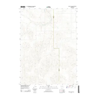
2014 Map of Hagan Lake NW
USGS Topo · Published 2014About this map
Brown and Rock counties meet along a high-plains boundary defined by subtle drainage patterns and agricultural section lines. The northern portion of the landscape is carved by Long Pine Creek, which meanders across the northwest corner, while the smaller Spring Branch feeds into the local hydrology further east. This 2014 survey reveals a sparsely populated region where the environment is characterized by the rolling contours of the Nebraska Sandhills. The lack of concentrated settlements or named towns highlights the rural and remote nature of the terrain during this era, where land use is dictated by the natural flow of water and the established county lines.
Find a feature on this map
3 named features on this map. Tap any name to fly to it.
Don’t see what you’re looking for? This feature index may not catch every label — zoom into the map to look around manually.
Map Details
Editions of this 2014 Hagan Lake NW Map
This is the sole edition of this map. No revisions or reprints were ever made.
Other maps of this area

1954 · Ainsworth
USGS Topo · 1:24,000

1954 · Long Pine
USGS Topo · 1:24,000

1954 · Bassett
USGS Topo · 1:24,000

1955 · O'Neill
USGS Topo · 1:250,000

1959 · O'Neill
USGS Topo · 1:250,000

1969 · O'Neill
USGS Topo · 1:250,000

1982 · Hagan Lake NE
USGS Topo · 1:24,000

1982 · Hofeld Lake
USGS Topo · 1:24,000

1982 · Raven
USGS Topo · 1:24,000
1982 · Lake George
USGS Topo · 1:24,000