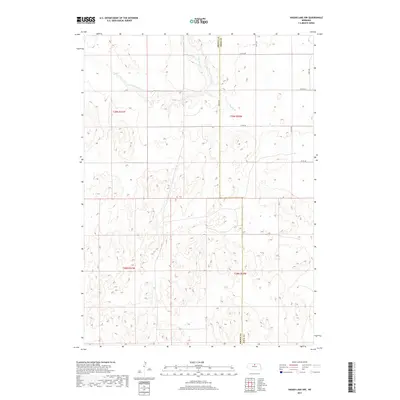
2017 Map of Hagan Lake NW
USGS Topo · Published 2017About this map
The rolling Sandhills terrain of northern Nebraska defines this landscape, where the boundary between Brown Co and Rock Co bisects a region primarily shaped by intermittent watercourses and section-line roads. This high plains environment is drained by the meandering path of Long Pine Cr in the northwest, supplemented by the smaller Spring Br to the east. The map illustrates a sparse, ranch-oriented settlement pattern typical of the early 21st century, where human presence is marked by a precise grid of rural routes including 874th Rd, 440th Ave, and 871st Rd. The land is meticulously organized under the Public Land Survey System, shown through the boundaries of t29n r21w and t28n r20w, which reflect the historical township and range framework that governed the settlement of the Nebraska frontier.
Find a feature on this map
15 named features on this map. Tap any name to fly to it.
Don’t see what you’re looking for? This feature index may not catch every label — zoom into the map to look around manually.
Map Details
Editions of this 2017 Hagan Lake NW Map
This is the sole edition of this map. No revisions or reprints were ever made.
Other maps of this area

1954 · Ainsworth
USGS Topo · 1:24,000

1954 · Long Pine
USGS Topo · 1:24,000

1954 · Bassett
USGS Topo · 1:24,000

1955 · O'Neill
USGS Topo · 1:250,000

1959 · O'Neill
USGS Topo · 1:250,000

1969 · O'Neill
USGS Topo · 1:250,000

1982 · Hagan Lake NE
USGS Topo · 1:24,000

1982 · Hofeld Lake
USGS Topo · 1:24,000

1982 · Raven
USGS Topo · 1:24,000
1982 · Lake George
USGS Topo · 1:24,000