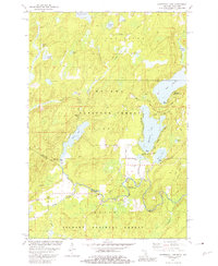
1981 Map of Hagerman Lake
USGS Topo · Published 1981About this map
Nelma sits at the southern edge of this Michigan-Wisconsin borderlands survey, where the Brule River winds through the dense forests of the Upper Peninsula and northern Wisconsin. This 1981 record documents a landscape dominated by the Ottawa National Forest and Nicolet National Forest, revealing a network of water bodies including Hagerman Lake, Brule Lake, and Ottawa Lake. The presence of an Old Railroad Grade running north-south on the eastern side of the map provides evidence of earlier timber harvesting or industrial transport that once serviced this remote region. From the many smaller lakes like Lake Twentytwo and Gadwall Lake to the scattered gravel pits, the map illustrates the transition from active extraction to recreational use as seen at the Hagerman Lake Recreation Area.
Find a feature on this map
35 named features on this map. Tap any name to fly to it.
Don’t see what you’re looking for? This feature index may not catch every label — zoom into the map to look around manually.
Map Details
Editions of this 1981 Hagerman Lake Map
This is the sole edition of this map. No revisions or reprints were ever made.
Other maps of this area

1898 · Iron River
USGS Topo · 1:62,500

1938 · Alvin
USGS Topo · 1:48,000

1939 · Long Lake
USGS Topo · 1:48,000

1944 · Iron River
USGS Topo · 1:24,000

1945 · Gibbs City
USGS Topo · 1:24,000

1946 · Iron River
USGS Topo · 1:31,680

1946 · Alvin
USGS Topo · 1:48,000

1946 · Gibbs City
USGS Topo · 1:31,680

1948 · Long Lake
USGS Topo · 1:48,000

1954 · Iron Mountain
USGS Topo · 1:250,000