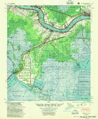
1955 Map of Hahnville
USGS Topo · Published 1955About this map
The Mississippi River defines the industrial and residential spine of this mid-century Louisiana landscape, winding past established communities like Hahnville, Destrehan, and Luling. This survey documents a critical era of flood control and infrastructure, clearly marking the massive Bonnet Carre Floodway and the historical scar of the Davis Crevasse of 1884. To the north, the burgeoning Moisant International Airport near Kenner signals the region's post-war modernization, while the southern reaches remain dominated by the intricate wetlands of Lake Salvador and the New Orleans Netherlands Drainage District. This transition from the high-ground river levees, populated with settlements like Killona and Norco, to the vast marshlands of Lafourche Parish reveals the unique topography that dictated human settlement. The map captures a complex network of bayous, including Bayou Des Allemands, alongside the heavy rail infrastructure of the Southern Pacific Railroad and the Illinois Central Railroad.
Find a feature on this map
99 named features on this map. Tap any name to fly to it.
Don’t see what you’re looking for? This feature index may not catch every label — zoom into the map to look around manually.
Map Details
Editions of this 1955 Hahnville Map
This is the sole edition of this map. No revisions or reprints were ever made.
Other maps of this area

1891 · Hahnville
USGS Topo · 1:62,500

1891 · Spanish Fort
USGS Topo · 1:62,500

1891 · New Orleans
USGS Topo · 1:62,500

1892 · Barataria
USGS Topo · 1:62,500

1892 · Lac Des Allemands
USGS Topo · 1:62,500

1892 · Mount Airy
USGS Topo · 1:62,500

1892 · Bonnet Carre
USGS Topo · 1:62,500

1892 · Cut-Off
USGS Topo · 1:62,500

1892 · Houma
USGS Topo · 1:62,500

1932 · New Orleans NW
USGS Topo · 1:31,680