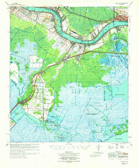
1969 Map of Hahnville
USGS Topo · Published 1971About this map
The Mississippi River winds through this 1969 survey, bordered by essential mid-century infrastructure like the Kenner Revetment and the sprawling Bonnet Carre Floodway. This corridor in St. Charles Parish shows a complex landscape of traditional riverfront settlements like Hahnville and Destrehan alongside a burgeoning petroleum economy. Extensive extraction sites, including the Boutte Oil and Gas Field and Paradis Oil and Gas Field, dominate the transition from the levee lands to the southern marshes.
Find a feature on this map
87 named features on this map. Tap any name to fly to it.
Don’t see what you’re looking for? This feature index may not catch every label — zoom into the map to look around manually.
Map Details
Editions of this 1969 Hahnville Map
This is the sole edition of this map. No revisions or reprints were ever made.
Other maps of this area

1891 · Hahnville
USGS Topo · 1:62,500

1891 · Spanish Fort
USGS Topo · 1:62,500

1891 · New Orleans
USGS Topo · 1:62,500

1892 · Barataria
USGS Topo · 1:62,500

1892 · Lac Des Allemands
USGS Topo · 1:62,500

1892 · Mount Airy
USGS Topo · 1:62,500

1892 · Bonnet Carre
USGS Topo · 1:62,500

1892 · Cut-Off
USGS Topo · 1:62,500

1892 · Houma
USGS Topo · 1:62,500

1932 · New Orleans NW
USGS Topo · 1:31,680