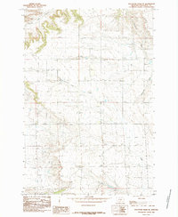
1985 Map of Hailstone Basin SE
USGS Topo · Published 1985About this map
Gooseneck Creek and Lost Creek carve through this high Montana basin in the mid-1980s, revealing a landscape defined by ranching infrastructure and subtle drainage patterns. The terrain near Painted Robe is punctuated by functional landmarks of the era, including scattered Storage bins and a small Gravel Pit indicative of local maintenance and industry. For local history researchers, the map identifies a small Cem located near the upper reaches of Gooseneck Creek, providing a specific point of interest for genealogical study. The presence of a named Spring and Robe Creek in the northwest corner highlights the critical importance of water sources in this Stillwater County environment.
Find a feature on this map
8 named features on this map. Tap any name to fly to it.
Don’t see what you’re looking for? This feature index may not catch every label — zoom into the map to look around manually.
Map Details
Editions of this 1985 Hailstone Basin SE Map
This is the sole edition of this map. No revisions or reprints were ever made.
Other maps of this area

1889 · Big Snowy Mountain
USGS Topo · 1:250,000

1892 · Stillwater
USGS Topo · 1:125,000

1893 · Big Snowy Mountain
USGS Topo · 1:250,000

1954 · Billings
USGS Topo · 1:250,000

1954 · Roundup
USGS Topo · 1:250,000

1956 · Battle Butte
USGS Topo · 1:24,000

1956 · Wheat Basin
USGS Topo · 1:24,000

1956 · Rock Spring
USGS Topo · 1:24,000

1957 · Billings
USGS Topo · 1:250,000

1958 · Billings
USGS Topo · 1:250,000