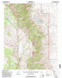
1994 Map of Haiwee Pass
USGS Topo · Published 1997About this map
Inyo National Forest and Sequoia National Forest meet in this high-altitude landscape where the southern Sierra Nevada transitions into the Owens Valley. The map documents a rugged alpine wilderness defined by steep elevation changes, showing the Pacific Crest Scenic Trail as it winds south toward the South Fork Kern River. This 1990s revision captures the complex water network of the Eastern Sierra, from the numerous high-country seeps and springs to the engineered Aqueduct on the valley floor. Evidence of human movement and industry is visible in the Old Railroad Grade and an Open Pit Mine, while natural landmarks like La Hogback and Round Mountain anchor the terrain. The boundary between Tulare and Inyo counties splits the sheet, marking the divide between the high river drainages and the arid basin to the east.
Find a feature on this map
33 named features on this map. Tap any name to fly to it.
Don’t see what you’re looking for? This feature index may not catch every label — zoom into the map to look around manually.
Map Details
Editions of this 1994 Haiwee Pass Map
This is the sole edition of this map. No revisions or reprints were ever made.
Other maps of this area

1905 · Olancha
USGS Topo · 1:125,000

1907 · Olancha
USGS Topo · 1:125,000

1908 · Ballarat
USGS Topo · 1:250,000

1913 · Ballarat
USGS Topo · 1:250,000

1948 · Death Valley
USGS Topo · 1:250,000

1948 · Fresno
USGS Topo · 1:250,000

1951 · Keeler
USGS Topo · 1:62,500

1951 · Haiwee Reservoir
USGS Topo · 1:62,500

1954 · Death Valley
USGS Topo · 1:250,000

1955 · Fresno
USGS Topo · 1:250,000