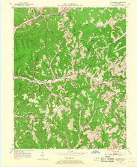
1953 Map of Haldeman
USGS Topo · Published 1968About this map
The Chesapeake and Ohio railroad corridor anchors the northern edge of this terrain, connecting the settlements of Gates, Hays Crossing, and Haldeman. This 1950s landscape is deeply carved by the waters of Triplett Creek and Christy Creek, where the local economy and social life were defined by small, isolated mountain communities. The concentration of rural infrastructure reveals a highly decentralized population during the mid-century period, with numerous neighborhood institutions such as the Wes Cox Sch, Poplar Grove Sch, and Dittney Ch serving residents in the hollows. Evidence of local industry appears at a Quarry near Christy, while the sprawling boundaries of the Cumberland National Forest dominate the western and southern reaches of the quadrangle. For genealogists, the map is a primary record of family-named landmarks including the Newell Cem and Christian Cem.
Find a feature on this map
55 named features on this map. Tap any name to fly to it.
Don’t see what you’re looking for? This feature index may not catch every label — zoom into the map to look around manually.
Map Details
Editions of this 1953 Haldeman Map
2 editions found
Other maps of this area

1929 · Morehead
USGS Topo · 1:48,000

1935 · Morehead
USGS Topo · 1:62,500

1950 · Olive Hill
USGS Topo · 1:24,000

1950 · Ault
USGS Topo · 1:24,000

1950 · Sandy Hook
USGS Topo · 1:24,000

1951 · Soldier
USGS Topo · 1:24,000

1951 · Cranston
USGS Topo · 1:24,000

1953 · Haldeman
USGS Topo · 1:24,000

1953 · Bangor
USGS Topo · 1:24,000
1953 · Wrigley
USGS Topo · 1:24,000