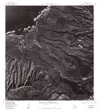
1977 Map of Haleiwa
USGS Topo · Published 1984About this map
Haleiwa and the surrounding North Shore landscape are captured in this 1977 orthophotoquad, showing the transition from the coastal settlement to the agricultural uplands. The imagery reveals the intricate patterns of fields and gulches that characterize this part of Oahu, leading southward toward Wahiawa. The prominent coastal landmark of Puaena Point stands at the edge of the Pacific Ocean, marking the entrance to the bay. To the south, the structured layout of Schofield Barracks is visible, reflecting the significant military presence that shaped the region's development during the late twentieth century. Unlike a standard topographic map, this photographic survey provides a direct view of land use, forest cover, and the built environment at a time when the sugar industry and military operations remained central to the island's economy.
Find a feature on this map
5 named features on this map. Tap any name to fly to it.
Don’t see what you’re looking for? This feature index may not catch every label — zoom into the map to look around manually.
Map Details
Editions of this 1977 Haleiwa Map
This is the sole edition of this map. No revisions or reprints were ever made.
Other maps of this area

1952 · Waimea
USGS Topo · 1:24,000

1953 · Haleiwa
USGS Topo · 1:24,000

1953 · Schofield Barracks
USGS Topo · 1:24,000

1953 · Hauula
USGS Topo · 1:24,000

1954 · Oahu
USGS Topo · 1:250,000

1954 · Waianae
USGS Topo · 1:24,000

1954 · Kahuku
USGS Topo · 1:24,000

1954 · Kaena
USGS Topo · 1:24,000

1954 · Waipahu
USGS Topo · 1:24,000

1959 · Waipahu
USGS Topo · 1:24,000