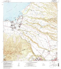
1983 Map of Haleiwa
USGS Topo · Published 1983About this map
The coastal settlements of Haleiwa and Waialua anchor this 1983 revision, showcasing the intricate water management systems of Oahu's North Shore. The landscape is defined by the transition from the Pacific Ocean at Waialua Bay to the rising elevations of the Waianae Range. Inland, the map reveals the legacy of the plantation era with residential clusters like Opaeula Camp 3, Kemoo Camp 4, and Poamoho Camp, all supported by a complex network of ditches and reservoirs including Kaheaka Res and the Wahiawa Reservoir.
Find a feature on this map
64 named features on this map. Tap any name to fly to it.
Don’t see what you’re looking for? This feature index may not catch every label — zoom into the map to look around manually.
Map Details
Editions of this 1983 Haleiwa Map
This is the sole edition of this map. No revisions or reprints were ever made.
Other maps of this area

1952 · Waimea
USGS Topo · 1:24,000

1953 · Haleiwa
USGS Topo · 1:24,000

1953 · Schofield Barracks
USGS Topo · 1:24,000

1953 · Hauula
USGS Topo · 1:24,000

1954 · Oahu
USGS Topo · 1:250,000

1954 · Waianae
USGS Topo · 1:24,000

1954 · Kahuku
USGS Topo · 1:24,000

1954 · Kaena
USGS Topo · 1:24,000

1954 · Waipahu
USGS Topo · 1:24,000

1959 · Waipahu
USGS Topo · 1:24,000