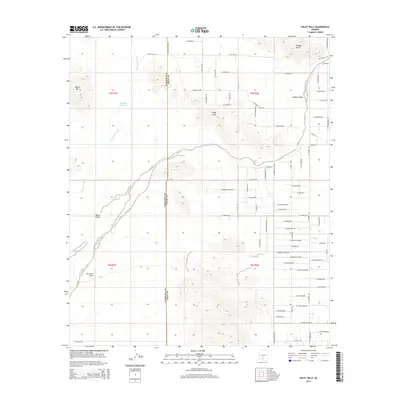
2014 Map of Haley Hills
USGS Topo · Published 2014About this map
Vekol Valley defines the lower reaches of this desert landscape where seasonal drainage systems converge. The map documents a transition from the rugged topography of the Booth Hills and Haley Hills into the flatter basins of Hidden Valley. Water management in this arid environment is highlighted by the presence of Poverty Flat Tank and the braided paths of Waterman Wash and Vekol Wash. Settlement patterns are marked by a rectilinear grid of local roads extending into the valley floor, alongside the specialized infrastructure of the G.M. Ranch Airport. Notable landforms such as Papago Butte anchor the northern boundary, while the shared border between Maricopa County and Pinal County bisects the survey area, showing how modern political boundaries cut across the natural terrain.
Find a feature on this map
76 named features on this map. Tap any name to fly to it.
Don’t see what you’re looking for? This feature index may not catch every label — zoom into the map to look around manually.
Map Details
Editions of this 2014 Haley Hills Map
This is the sole edition of this map. No revisions or reprints were ever made.
Other maps of this area

1913 · Maricopa
USGS Topo · 1:62,500

1915 · Maricopa
USGS Topo · 1:62,500

1946 · Antelope Peak
USGS Topo · 1:62,500

1948 · Antelope Peak
USGS Topo · 1:62,500

1951 · Estrella
USGS Topo · 1:62,500

1951 · Mobile
USGS Topo · 1:62,500

1952 · Maricopa
USGS Topo · 1:24,000

1952 · Enid
USGS Topo · 1:24,000
1952 · Maricopa
USGS Topo · 1:62,500

1953 · Ajo
USGS Topo · 1:250,000