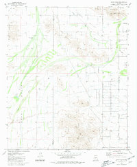
1981 Map of Haley Hills
USGS Topo · Published 1981About this map
Haley Hills and the Boot Hills dominate this arid landscape on the border of Maricopa and Pinal counties. Surveyed in the late 1970s, the terrain is defined by complex drainage systems, most notably the wide path of Vekol Wash as it moves through the desert floor. This area represents a transition between the elevated peaks of the Palo Verde Mountains and the lower alluvial plains of Hidden Valley.
Find a feature on this map
14 named features on this map. Tap any name to fly to it.
Don’t see what you’re looking for? This feature index may not catch every label — zoom into the map to look around manually.
Map Details
Editions of this 1981 Haley Hills Map
This is the sole edition of this map. No revisions or reprints were ever made.
Other maps of this area

1913 · Maricopa
USGS Topo · 1:62,500

1915 · Maricopa
USGS Topo · 1:62,500

1946 · Antelope Peak
USGS Topo · 1:62,500

1948 · Antelope Peak
USGS Topo · 1:62,500

1951 · Estrella
USGS Topo · 1:62,500

1951 · Mobile
USGS Topo · 1:62,500

1952 · Maricopa
USGS Topo · 1:24,000

1952 · Enid
USGS Topo · 1:24,000
1952 · Maricopa
USGS Topo · 1:62,500

1953 · Ajo
USGS Topo · 1:250,000