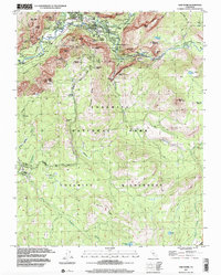
1997 Map of Half Dome
USGS Topo · Published 2002About this map
The Merced River flows through the heart of this valley, centering a landscape defined by dramatic geological features and early-twentieth-century park architecture. Established hospitality centers like the Ahwahnee Hotel and Curry Village sit along the valley floor, connected by Northside Drive and Southside Drive. The topography transitions sharply from the meadows of Yosemite Village to the heights of Half Dome and Mount Starr King. The map illustrates a complex network of established routes, including the John Muir Trail and Mist Trail, which navigate the steep elevations near Vernal Fall and Nevada Fall. In the southern reaches, higher-elevation features like Ostrander Lake and Mono Meadow reflect the wilderness character of the park's interior, away from the bustling visitor hubs of the valley. This 1997 photo-inspection captures the enduring infrastructure of Yosemite National Park at a time when its most famous natural landmarks remained the primary draw for global travelers.
Find a feature on this map
78 named features on this map. Tap any name to fly to it.
Don’t see what you’re looking for? This feature index may not catch every label — zoom into the map to look around manually.
Map Details
Editions of this 1997 Half Dome Map
This is the sole edition of this map. No revisions or reprints were ever made.
Other maps of this area

1897 · Yosemite
USGS Topo · 1:125,000

1900 · Yosemite
USGS Topo · 1:125,000

1901 · Mt. Lyell
USGS Topo · 1:125,000

1903 · Yosemite
USGS Topo · 1:125,000

1909 · Yosemite
USGS Topo · 1:125,000

1947 · Mariposa
USGS Topo · 1:250,000

1948 · Mariposa
USGS Topo · 1:250,000

1953 · Merced Peak
USGS Topo · 1:62,500

1956 · Hetch Hetchy Reservoir
USGS Topo · 1:62,500

1956 · Tuolumne Meadows
USGS Topo · 1:62,500