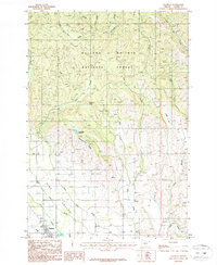
1987 Map of Halfway
USGS Topo · Published 1987About this map
The town of Halfway sits at the southwestern edge of this landscape, positioned where the rugged drainages of the Wallowa Whitman National Forest meet the flatter reaches of Pine Valley Creek. Compiled from 1980s aerial photography, the map reveals a network of mountain streams including Clarks Creek, East Pine Creek, and Beecher Creek that carve through the timbered heights. High-elevation landmarks like Mehlhorn Butte and the long expanse of Bearwallow Ridge dominate the central terrain, while the Bearwallow Reservoir serves as a critical water resource for the valley below. To the east, the map tracks the smaller settlement of Sunset and the drainage of Dry Creek. The contrast between the systematic forestry of the northern mountains and the established irrigation and settlement patterns in the valley floor illustrates the dual economy of this Baker County region.
Find a feature on this map
24 named features on this map. Tap any name to fly to it.
Don’t see what you’re looking for? This feature index may not catch every label — zoom into the map to look around manually.
Map Details
Editions of this 1987 Halfway Map
This is the sole edition of this map. No revisions or reprints were ever made.
Other maps of this area

1915 · Pine
USGS Topo · 1:125,000

1954 · Cornucopia
USGS Topo · 1:62,500

1955 · Baker
USGS Topo · 1:250,000

1955 · Grangeville
USGS Topo · 1:250,000

1957 · Halfway
USGS Topo · 1:62,500

1957 · Homestead
USGS Topo · 1:62,500

1957 · Copperfield
USGS Topo · 1:62,500

1959 · Baker
USGS Topo · 1:250,000

1959 · Grangeville
USGS Topo · 1:250,000

1980 · McCall
USGS Topo · 1:100,000