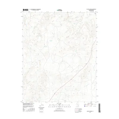
2016 Map of Halfway Creek
USGS Topo · Published 2016About this map
Halfway Creek and Parker Creek carve paths through this section of the Texas Panhandle, defining a landscape traditionally used for large-scale ranching operations. The area is characterized by a sophisticated water management network of named livestock tanks, which are essential for supporting cattle in this arid environment. Significant landmarks include Big Halfway Tank, Little Halfway Tank, and several specialized sites like Horse Trap Tank and Bull Tub Tank. The presence of these named water features alongside Ranch Creek suggests a long history of pastoral land use, with Everett Rd providing one of the few formal transportation corridors through the undulating terrain of Oldham County. Further east, Cottonwood Creek flows toward the quadrant boundary, marking the varied drainage patterns that historically dictated settlement and grazing routes in this part of Texas.
Find a feature on this map
17 named features on this map. Tap any name to fly to it.
Don’t see what you’re looking for? This feature index may not catch every label — zoom into the map to look around manually.
Map Details
Editions of this 2016 Halfway Creek Map
This is the sole edition of this map. No revisions or reprints were ever made.
Other maps of this area

1934 · Ady
USGS Topo · 1:62,500

1936 · Ady
USGS Topo · 1:62,500

1954 · Tucumcari
USGS Topo · 1:250,000

1958 · Tucumcari
USGS Topo · 1:250,000

1966 · Jay Taylor Ranch
USGS Topo · 1:24,000

1966 · Halfway Creek
USGS Topo · 1:24,000

1966 · Ady
USGS Topo · 1:24,000

1966 · Rotten Hill
USGS Topo · 1:24,000

1966 · Torrea Peak
USGS Topo · 1:24,000
1966 · Vega North
USGS Topo · 1:24,000