
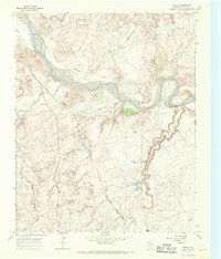
1966 Map of Rotten Hill
USGS Topo · Published 1969About this map
The rugged ranchlands along the border of Oldham and Potter counties are defined here by a network of seasonal watercourses and critical water infrastructure. In a landscape where surface water is scarce, named windmills such as the Wildorado Windmill, Shipping Pasture Windmill, and Cactus Flat Windmill reveal the essential reliance on groundwater for the local cattle industry. The terrain is marked by distinctive formations like the Five Fingers and Rotten Hill, while the Blue Hole serves as a notable landmark near Daniels Creek. This 1966 field-checked survey captures the area before modern developments, showing the remote Wildorado Camp and a system of unimproved ranch roads like Goodman and Hand Dr that provided the only access through the breaks and draws of Cruz de la Creek and Wildorado Creek.
Find a feature on this map
28 named features on this map. Tap any name to fly to it.
Don’t see what you’re looking for? This feature index may not catch every label — zoom into the map to look around manually.
Map Details
Editions of this 1966 Rotten Hill Map
This is the sole edition of this map. No revisions or reprints were ever made.
Other maps of this area

1934 · Ady
USGS Topo · 1:62,500

1936 · Ady
USGS Topo · 1:62,500

1954 · Tucumcari
USGS Topo · 1:250,000

1958 · Tucumcari
USGS Topo · 1:250,000

1962 · Wildorado
USGS Topo · 1:62,500

1965 · Everett
USGS Topo · 1:24,000
1966 · Boden
USGS Topo · 1:24,000

1966 · Jay Taylor Ranch
USGS Topo · 1:24,000

1966 · Halfway Creek
USGS Topo · 1:24,000

1966 · Ady
USGS Topo · 1:24,000