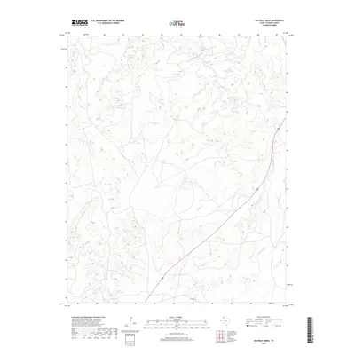
2019 Map of Halfway Creek
USGS Topo · Published 2019About this map
Halfway Cr and Parker Cr weave through this section of the Texas Panhandle, defining a landscape shaped by intermittent water and ranching infrastructure. The drainage systems of Ranch Cr and Cottonwood Cr provide natural contours in an otherwise open terrain, where water management is centralized in numerous named livestock tanks. These reservoirs, including Trujillo Tank, Caliche Tank, and Rincon Tank, are essential markers for local history and land usage. Transportation is largely limited to the south, where Everett Rd provides access across the arid plains. The presence of specialized catchments like Horse Trap Tank and Bull Pab Tank highlights the enduring cattle-ranching heritage of Oldham County, while the varied elevations around Big Halfway Tank and Little Halfway Tank offer insight into the hydrology of the High Plains.
Find a feature on this map
17 named features on this map. Tap any name to fly to it.
Don’t see what you’re looking for? This feature index may not catch every label — zoom into the map to look around manually.
Map Details
Editions of this 2019 Halfway Creek Map
This is the sole edition of this map. No revisions or reprints were ever made.
Other maps of this area

1934 · Ady
USGS Topo · 1:62,500

1936 · Ady
USGS Topo · 1:62,500

1954 · Tucumcari
USGS Topo · 1:250,000

1958 · Tucumcari
USGS Topo · 1:250,000

1966 · Jay Taylor Ranch
USGS Topo · 1:24,000

1966 · Halfway Creek
USGS Topo · 1:24,000

1966 · Ady
USGS Topo · 1:24,000

1966 · Rotten Hill
USGS Topo · 1:24,000

1966 · Torrea Peak
USGS Topo · 1:24,000
1966 · Vega North
USGS Topo · 1:24,000