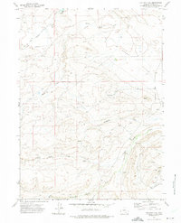
1971 Map of Halfway Hill
USGS Topo · Published 1975About this map
Kyle Oil Camp and its associated industrial activity define this pocket of Carbon County in the early 1970s. The landscape is marked by a complex network of resource extraction and transport, including multiple Drill Holes, a long-distance Pipeline, and a Landing Strip situated near the southeastern corner of the map. The influence of earlier infrastructure is visible in the Old RR Grade that cuts across the northern terrain alongside Carbon Creek.
Find a feature on this map
19 named features on this map. Tap any name to fly to it.
Don’t see what you’re looking for? This feature index may not catch every label — zoom into the map to look around manually.
Map Details
Editions of this 1971 Halfway Hill Map
This is the sole edition of this map. No revisions or reprints were ever made.
Other maps of this area

1914 · Saddleback Hills
USGS Topo · 1:62,500

1915 · Como Ridge
USGS Topo · 1:48,000

1918 · Como Ridge
USGS Topo · 1:62,500

1921 · Saddleback Hills
USGS Topo · 1:62,500

1954 · Rawlins
USGS Topo · 1:250,000

1955 · Elk Mountain
USGS Topo · 1:24,000

1958 · Rawlins
USGS Topo · 1:250,000

1958 · Mc Fadden
USGS Topo · 1:24,000

1958 · T L Ranch
USGS Topo · 1:24,000

1962 · Rawlins
USGS Topo · 1:250,000